1939 Map CENTRAL EUROPE & MEDITERRANEAN Germany Poland Slovakia Palestine Levant For Sale


When you click on links to various merchants on this site and make a purchase, this can result in this site earning a commission. Affiliate programs and affiliations include, but are not limited to, the eBay Partner Network.

1939 Map CENTRAL EUROPE & MEDITERRANEAN Germany Poland Slovakia Palestine Levant:
$14.99
Large-formatfold-out 1939 map of Central Europe and the Mediterranean,printed more than 84 years ago. - This map opens to a generous26" x 36" and is drawn on a scale of 1:5,000,000.
- The coverage area extends from Ireland to the VolgaRiver, south to Libya and thecoast of northern Africa.
- Detailsinclude cities, towns, railroads, canals, natural features, andpolitical boundaries, some of whichare very different from today's.
- There is no Austria. Along with the western part ofCzechoslovakia, it had been annexed by Germany the yearbefore this map was printed.
- Poland's Baltic coastline is shown as shorter than it istoday, although the country's overall land area has been greatlydiminished.
- In the Middle East an area labeled Palestine occupieswhat is Israel today. North and east of Palestine arethe Levant States and Trans-Jordan.
- The map wascompiled by the Cartographic Division of the National GeographicSociety, and it was issued as a supplement to the magazine in October1939.
- Condition: It is in excellent condition,bright andclean, with no marks, rips, or tears. It is blankon the back, with no printingon the reverse side, and it folds to 9" x 6¾". Please see the scans andfeel free to ask any questions.
- Buy with confidence! We are always happy to combineshipping on thepurchase of multiple items — just make sure to pay for everythingat one time, not individually.
Powered by SixBit's eCommerce Solution
|
|
Other Related Items:
Related Items: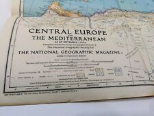
9/1/1939 Central Europe And The Mediterranean Supplemental Map start of WWII $105.00
1939 Japanese Safety Agency Large Antique Map of Hawaii, Pacific - Pearl Harbor $467.50
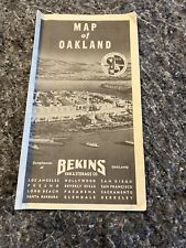
1939 Map of Oakland Bekins Van and Storage, Folded Map $39.95
|